


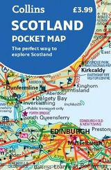
Scotland Pocket Map
The Perfect Way to Explore Scotland
Seiten
2018
|
New edition
Collins (Verlag)
978-0-00-822506-3 (ISBN)
Collins (Verlag)
978-0-00-822506-3 (ISBN)
- Titel erscheint in neuer Auflage
- Artikel merken
Zu diesem Artikel existiert eine Nachauflage
Explore new places with handy pocket maps from Collins.
Handy little full colour map of Scotland. Excellent value and very detailed for its size. Double-sided folded map with the Central Belt, southern Scotland and northern England on one side and northern Scotland including Orkney and Shetland on the reverse.
This map features:
• Clear mapping at a scale of 8.7 miles to 1 inch
• National Tourist Routes showing best routes through the most scenic areas
• Top 100 places of interest
• Park and Ride locations
• Ideal companion to a sat-nav – it enables route planning and route sense-checking
Essential for those planning a trip or who want an inexpensive and easy-to-use back up for a sat-nav.
Explore the world through accurate and up-to-date mapping.
| Erscheint lt. Verlag | 8.2.2018 |
|---|---|
| Zusatzinfo | Index |
| Verlagsort | London |
| Sprache | englisch |
| Maße | 90 x 140 mm |
| Gewicht | 40 g |
| Themenwelt | Reisen ► Karten / Stadtpläne / Atlanten ► Europa |
| ISBN-10 | 0-00-822506-0 / 0008225060 |
| ISBN-13 | 978-0-00-822506-3 / 9780008225063 |
| Zustand | Neuware |
| Informationen gemäß Produktsicherheitsverordnung (GPSR) | |
| Haben Sie eine Frage zum Produkt? |
Mehr entdecken
aus dem Bereich


aus dem Bereich
Karte (gefalzt) (2024)
Freytag-Berndt und ARTARIA (Verlag)
CHF 18,95
Georgien, Armenien, Aserbaidschan
Karte (gefalzt) (2025)
Freytag-Berndt und ARTARIA (Verlag)
CHF 24,90