


Imray Chart G28
Nisos Khios & the Coast of Turkey
Seiten
2013
Imray, Laurie, Norie & Wilson Ltd (Verlag)
978-1-84623-574-0 (ISBN)
Imray, Laurie, Norie & Wilson Ltd (Verlag)
978-1-84623-574-0 (ISBN)
- Titel erscheint in neuer Auflage
- Artikel merken
Zu diesem Artikel existiert eine Nachauflage
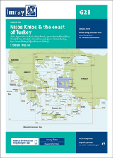
Plans included: Approaches to Psara (Nisos Psara) (1:15,000) Approaches to Khios (Nisos Khios) (1:20,000) Ormos Mandraki (Nisos Oinoussa) (1:8,000) Cesme Korfezi (Turkey) (1:18,000) Foca Limani (Turkey) (1:20,000) Sigacik Limani (Turkey) (1:18,000) On this 2013 edition full details of the new TSS schemes are shown at Izmir Korfezi, Candarli Korfezi and Nemrut Koyu; revised depths and harbour developments are shown at Psara, Khios, Cesme and Foca; the Sigacik Limani sketch plan has been replaced with a fully WGS84-compatible version; the latest known depths, restricted areas and marine farms have been applied to the main chart; and details of the recently deployed AIS transmitters are shown across the chart.
| Erscheint lt. Verlag | 1.12.2013 |
|---|---|
| Verlagsort | Huntingdon |
| Sprache | englisch |
| Maße | 210 x 295 mm |
| Themenwelt | Sachbuch/Ratgeber ► Sport ► Segeln / Tauchen / Wassersport |
| Reisen ► Karten / Stadtpläne / Atlanten ► Europa | |
| Technik ► Fahrzeugbau / Schiffbau | |
| ISBN-10 | 1-84623-574-X / 184623574X |
| ISBN-13 | 978-1-84623-574-0 / 9781846235740 |
| Zustand | Neuware |
| Informationen gemäß Produktsicherheitsverordnung (GPSR) | |
| Haben Sie eine Frage zum Produkt? |
Mehr entdecken
aus dem Bereich


aus dem Bereich
Karte/Kartografie (2025)
Delius Klasing (Verlag)
CHF 96,90
Karte/Kartografie (2025)
Delius Klasing (Verlag)
CHF 122,00