


Reeds Nautical Almanac 2027
Seiten
2026
Reeds (Verlag)
978-1-3994-3097-5 (ISBN)
Reeds (Verlag)
978-1-3994-3097-5 (ISBN)
- Noch nicht erschienen (ca. August 2026)
- Versandkostenfrei
- Auch auf Rechnung
- Artikel merken
The indispensable annual compendium of navigational data for anyone going to sea around the whole of the UK and the North Atlantic coast from Denmark to Gibraltar.
The indispensable trusted annual compendium of navigational data for yachtsmen and motorboaters.
Known as the Yachtsman's Bible, Reeds provides all the information required to navigate Atlantic coastal waters around the whole of the UK, Ireland, Channel Islands and the entire European coastline from the tip of Denmark right down to Gibraltar, Northern Morocco, the Azores and Madeira.
The 2027 Almanac continues the tradition of year-on-year improvement and meticulous presentation of all the data required for safe navigation. Now with an improved layout for easier reference and with over 45,000 annual changes, it is regarded as the essential almanac for anyone going to sea, and is recommended by the RYA, RNLI and Coastguard, and used in training courses all around the UK and Europe.
The 2027 edition is updated throughout and includes: 700 harbour chartlets; tide tables and tidal streams; buoyage and lights; 7,500 waypoints; invaluable passage notes; distance tables; radio, weather and safety information; and a first aid section. Also includes a free Reeds Marina Guide.
Also available: free supplements of up-to-date navigation changes from January to June at: www.reedsnauticalalmanac.co.uk
A lifelong sailing enthusiast, Simon Jollands has filmed many major sailing events as well as producing and directing several sea safety films for the RNLI. He is the co-founder of app developer Safe Skipper Apps, which specialises in producing nautical reference apps, and is author of The Boatyard Book, Safe Skipper, Reeds Lights, Shapes and Buoyage Handbook and Go Sailing, all published by Adlard Coles.
The print version includes: 700 chartlets, Harbour facilities, Tide tables and streams, 7,500 waypoints, International codes and flags, Weather, Distance tables, Passage advice, Area planning charts, Rules of the road, Radio information, Communications, Safety, Mayday and distress procedures, and Documentation and Customs.
| Erscheint lt. Verlag | 13.8.2026 |
|---|---|
| Reihe/Serie | Reed's Almanac |
| Zusatzinfo | Full colour harbour charts and diagrams throughout |
| Verlagsort | London |
| Sprache | englisch |
| Maße | 192 x 265 mm |
| Themenwelt | Sachbuch/Ratgeber ► Sport ► Segeln / Tauchen / Wassersport |
| Schulbuch / Wörterbuch ► Lexikon / Chroniken | |
| Technik ► Fahrzeugbau / Schiffbau | |
| ISBN-10 | 1-3994-3097-1 / 1399430971 |
| ISBN-13 | 978-1-3994-3097-5 / 9781399430975 |
| Zustand | Neuware |
| Informationen gemäß Produktsicherheitsverordnung (GPSR) | |
| Haben Sie eine Frage zum Produkt? |
Mehr entdecken
aus dem Bereich

aus dem Bereich
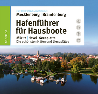
Müritz, Havel, Seenplatte : die schönsten Häfen und Liegeplätze
Buch | Hardcover (2025)
SD Media Services (Verlag)
CHF 51,90