


World For Kids, The, Poster Sized, Boxed
Wall Maps World
Seiten
2019
|
2019th ed.
National Geographic Maps (Verlag)
978-1-59775-595-5 (ISBN)
National Geographic Maps (Verlag)
978-1-59775-595-5 (ISBN)
- Titel ist leider vergriffen;
keine Neuauflage - Artikel merken
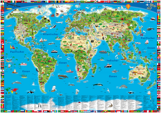
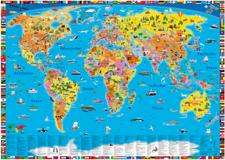
The World for Kids wall map is an enticing and engaging world map perfect for classroom, home or library. Recommended by geography educators for ages 7-12, this map features an optimized map design for readability and easy, intuitive learning. All 195 independent countries and their official, colorful flags are represented and arranged in alphabetical order for ease-of-use.
| Erscheint lt. Verlag | 10.11.2019 |
|---|---|
| Verlagsort | Evergreen |
| Sprache | englisch |
| Maße | 64 x 662 mm |
| Gewicht | 219 g |
| Themenwelt | Reisen ► Karten / Stadtpläne / Atlanten ► Welt / Arktis / Antarktis |
| Schulbuch / Wörterbuch ► Lexikon / Chroniken | |
| Sozialwissenschaften ► Pädagogik ► Schulpädagogik / Grundschule | |
| ISBN-10 | 1-59775-595-8 / 1597755958 |
| ISBN-13 | 978-1-59775-595-5 / 9781597755955 |
| Zustand | Neuware |
| Informationen gemäß Produktsicherheitsverordnung (GPSR) | |
| Haben Sie eine Frage zum Produkt? |
Mehr entdecken
aus dem Bereich
aus dem Bereich
Karte (gerollt) (2025)
Kümmerly+Frey (Verlag)
CHF 26,90