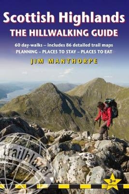
Scottish Highlands - the Hillwalking Guide
Trailblazer Publications (Verlag)
9781905864775 (ISBN)
- Titel erscheint in neuer Auflage
- Artikel merken
Scotland's Highlands and Islands contain some of the finest mountain scenery in Europe and by far the best way to experience it is on foot. Practical walking guide to over 80 hills in the Scottish Highlands and Islands. This Scottish hill-walking book covers Scottish hill walks, monros, corbetts and tracks including Ben Nevis walking guide and Cairngorm walks. Includes 90 detailed walking maps: walking times, directions, tricky junctions, places to stay, places to eat, points of interest written onto the map. These are not general-purpose maps but fully edited maps drawn by walkers for walkers. 60 day-walks for all abilities, graded for difficulty, 2-day and 3-day treks. Profile maps to show climbs and descents. Detailed accommodation: B&Bs, campsites, bunkhouses, bothies, hostels, hotels, pubs. Places to eat: cafes, pubs, teashops, restaurants. What to see. Guides to 62 gateway towns and villages. Detailed public transport information. *60 day-walks - for all abilities. Graded for difficulty, terrain and strenuousness. Selected from every corner of the region and ranging from well-known peaks such as Ben Nevis and Cairn Gorm to lesser-known hills such as Suilven and Clisham.*
2-day and 3-day treks - some of the walks have been linked to form multi-day treks such as the Great Traverse.*90 walking maps with unique mapping features - walking times, directions, tricky junctions, places to stay, places to eat, points of interest. These are not general-purpose maps but fully edited maps drawn by walkers for walkers. *Detailed public transport information *62 gateway towns and villages - Much more than just a walking guide, this book includes guides to 62 gateway towns and villages: what to see, where to eat, where to stay; pubs, hotels, B&Bs, campsites, bunkhouses, bothies, hostels.
Jim Manthorpe has trekked in many of the world's mountainous regions from Patagonia to the Himalaya and Scandinavia to the Canadian Rockies. He is the author of four other Trailblazer guidebooks: Great Glen Way, South Downs Way, Pembrokeshire Coast Path and Tour du Mont Blanc. He has also researched and updated numerous other Trailblazer titles. Jim lives on the west coast of the Scottish Highlands and now works as a wildlife cameraman and film-maker.
INTRODUCTION When to go 10 - Seasons 10 - Temperature 12 - Rainfall 13 - Daylight hours 13 - Annual events, festivals and Highland games 13 PART 1: PLANNING YOUR WALK Practical information for the hillwalker Accommodation 17 - Food 20 - Drink 22 - Information for foreign visitors 22 - Money 24 - Services 24 - Access 24 - Walking companies 25 What to take The pack on your back 27 - Footwear 27 - Clothes 28 - Toiletries 29 First-aid kit 29 - General items 29 - Sleeping kit 30 - Camping gear 30 - Bivvy gear 30 - Maps 31 - GPS 32 - Recommended reading 33 Getting to the Highlands Getting to Scotland 34 - Getting around the Highlands 35 PART 2: MINIMUM IMPACT WALKING Minimum impact walking Environmental impact 44 - Economic impact 46 Conservation Scottish Natural Heritage 47 - National parks 48 Other protected areas 49 PART 3: THE HIGHLANDS Facts about the Highlands Geography 51 - Geology 52 - History 53 - Language 55 Flora and fauna Mammals 56 - Birds 59 - Trees 64 - Flowers and plants 64 Lichens 66 PART 4: ROUTE GUIDE AND MAPS Using this guide 67 Loch Lomond and the Southern Highlands The mountains: Ben Ledi 879m 70 - The Cobbler 884m 71 - Ben Lomond 974m 74 - Ben Vorlich 943m 76 - Ben More 1174m & Stob Binnein 1165m 78 - Beinn Dorain 1076m & Beinn an Dothaidh 1004m 80 - Stob a' Choire Odhair 945m & Stob Ghabhar 1090m 83 Towns and villages: Callander 87 - Arrochar 90 - Rowardennan 91 - Inversnaid 92 - Ardlui 92 - Inverarnan 92 - Crianlarich 93 - Strathfillan 95 - Tyndrum 95 - Bridge of Orchy 96 PART 4: ROUTE GUIDE AND MAPS (continued) Glen Coe and Glen Nevis The mountains: Buachaille Etive Mor (Stob Dearg 1021m & Stob na Broige 956m) 98 - Aonach Eagach (Meall Dearg 953m & Sgorr nam Fiannaidh 967m) 100 - Stob Coire Sgreamhach 1072m, Bidean nam Bian 1150m & Stob Coire nan Lochan 1115m 104 - Ballachulish Horseshoe (Sgorr Dhearg 1024m & Sgorr Dhonuill 1001m) 108 - Stob Ban 999m & Mullach nan Coirean 939m 110 - Carn Mor Dearg 1220m & Ben Nevis 1344m 113 Towns and villages: Kingshouse 118 - Glen Coe 118 - Ballachulish 120 - Glen Nevis 121 - Fort William 122 The Central Highlands The mountains: Beinn Ghlas 1103m & Ben Lawers 1214m 128 - Schiehallion 1083m 130 - Sgor Iutharn 1028m, Geal Charn 1132m & Carn Dearg 1034m 132 - Ben Alder 1148m & Beinn Bheoil 1019m 137 - Creag Dhubh 757m 139 - Creag Meagaidh 1128m 140 - Stob Coire Easain 1115m & Stob a' Choire Mheadhoin 1105m 142 Towns and villages: Killin 148 - Laggan 149 - Dalwhinnie 150 - Tulloch 150 - Roybridge 150 - Corrour 151 The Cairngorms and Eastern Highlands The mountains: Ben Vrackie 841m 153 - Mayar 928m & Driesh 947m 155 - Carn a' Choire Bhoidheach 1110m & Lochnagar 1155m 157 - Derry Cairngorm 1155m, Ben Macdui 1309m & Carn a' Mhaim 1037m 162 - Braeriach 1296m, Sgor an Lochain Uaine 1258m, Cairn Toul 1291m & The Devil's Point 1004m 168 - Cairn Gorm 1244m 174 - Meall a'Bhuachaille 810m 176 Towns and villages: Pitlochry 179 - Clova 182 - Braemar 182 - Aviemore 183 - Glenmore 184 Sunart to Knoydart The mountains: Beinn Resipol 845m 186 - Sgurr Ghiubhsachain 849m & Sgorr Craobh a' Chaorainn 775m 188 - The Corryhully Horseshoe (Sgurr nan Coireachan 956m & Sgurr Thuilm 963m) 191 - Beinn Bhuidhe (Knoydart) 855m 195 - Ladhar Bheinn 1020m 199 - Sgurr a' Mhaoraich 1027m 204 Towns and villages: Strontian 206 - Glenfinnan 207 - Mallaig 208 - Inverie 209 - Kinlochhourn 210 - Barisdale 210 Glen Shiel to Torridon and Fisherfield The mountains: Beinn Sgritheall 974m 211 - The Saddle 1010m & Sgurr na Sgine 946m 214 - Sgurr na Lapaich 1036m, Mam Sodhail 1181m & Carn Eige 1183m 218 - Beinn Damh 902m 222 - Beinn Alligin (Tom na Gruagaich 922m & Sgurr Mhor 986m) 224 - Beinn Eighe (Spidean Coire nan Clach 993m & Ruadh-stac Mor 1010m) 226 PART 4: ROUTE GUIDE AND MAPS (continued) Glen Shiel to Torridon and Fisherfield (continued) Beinn an Eoin 855m 228 - A' Mhaigdean 967m & Ruadh Stac Mor 918m 231 - An Teallach (Bidean a' Ghlas Thuill 1062m & Sgurr Fiona 1060m) 236 Towns and villages: Glenelg 240 - Glen Shiel & Shiel Bridge 240 - Tomich 241 - Torridon 241 - Kinlochewe 242 - Poolewe 242 - Gairloch 242 - Dundonnell 243 The Far North The mountains: Stac Pollaidh 613m 244 - Suilven (Caisteal Liath 731m) 246 - Quinaig (Sail Gharbh 808m, Sail Gorm 776m & Spidean Coinich 764m) 248 - Ben Stack 721m 250 - Arkle 787m 251 - Ben Hope 927m 254 - Ben Loyal 764m 255 Towns and villages: Ullapool 257 - Lochinver 260 - Kylesku 261 - Scourie 261 - Durness 261 - Tongue 262 The Islands The mountains: Arran (Goatfell 874m 263) - Mull (Beinn Talaidh 762m 266) - Rum (Ainshval 781m & Askival 812m 269) - Skye (Bla Bheinn 928m 274; Sgurr nan Gillean 964m 275; Glamaig 775m 277; The Storr 719m 279) - South Uist (Beinn Mhor 620m, Ben Corodale 527m & Hecla 606m 280) - Harris (Ceapabhal 365m 284; Clisham 799m 286) - Lewis (Suaineabhal 429m 289) Towns and villages: Arran (Brodick 291) - Oban (for Mull) 292 - Mull (Craignure 294) - Rum (Kinloch 295) - Skye (Broadford 296; Torrin 296; Sligachan 296; Portree 297; Uig 298) - South Uist (Tobha Mor 300) - Harris (An t-Ob 300, An Taobh Tuath 300; Tarbert 300; Ardhasaig 302) - Lewis (Timsgearraidh 302) The Big Treks The Great Traverse - Corrour to Glen Nevis (via The Grey Corries, The Aonachs, Carn Mor Dearg & Ben Nevis), 2-3 days 303 Cairngorms - Aviemore to Linn of Dee, 2 days 307 Knoydart - Kinlochhourn to Inverie, 2 days 308 Five Sisters & Brothers of Kintail - Cluanie to Loch, 2-3 days 309 Fisherfield - Poolewe to Dundonnell, 2-3 days 315 APPENDICES A: Mountain safety 317 B: Gaelic 323 C: Glossary 325 D: Mountain photography 326 E: Map keys 327 INDEX 328
| Erscheinungsdatum | 19.01.2017 |
|---|---|
| Zusatzinfo | 10 black & white illustrations, 10 black & white halftones, 50 colour illustrations, 90 maps, 5 charts |
| Verlagsort | Hindhead, Surrey |
| Sprache | englisch |
| Maße | 122 x 180 mm |
| Gewicht | 310 g |
| Themenwelt | Sachbuch/Ratgeber ► Sport |
| Reiseführer ► Europa ► Großbritannien | |
| Reiseführer ► Europa ► Schottland | |
| ISBN-13 | 9781905864775 / 9781905864775 |
| Zustand | Neuware |
| Informationen gemäß Produktsicherheitsverordnung (GPSR) | |
| Haben Sie eine Frage zum Produkt? |
aus dem Bereich


