


John Muir Trail (topographic Map Guide)
National Geographic California
Seiten
2014
|
2024th ed.
National Geographic Maps (Verlag)
9781566956895 (ISBN)
National Geographic Maps (Verlag)
9781566956895 (ISBN)
National Geographic's Map Guide of the John Muir Trail is an indispensable tool for navigating one of the most famous trails in the United States. The maps start at the northern terminus in Yosemite Valley and progress along the ridge of the Sierra Nevada, past Devils Postpile, and end at the highest point in the lower 48 on the top of Mount Whitney. Along the way you will pass through; Yosemite National Park, Ansel Adams Wilderness, Devils Postpile National Monument, John Muir Wilderness, Kings Canyon National Park, and finally, Sequoia National Park & Mt Whitney.
| Erscheint lt. Verlag | 26.9.2014 |
|---|---|
| Zusatzinfo | 1 Illustrations, unspecified |
| Verlagsort | Evergreen |
| Sprache | englisch |
| Maße | 216 x 235 mm |
| Gewicht | 94 g |
| Themenwelt | Sachbuch/Ratgeber ► Sport |
| Reisen ► Karten / Stadtpläne / Atlanten | |
| ISBN-13 | 9781566956895 / 9781566956895 |
| Zustand | Neuware |
| Informationen gemäß Produktsicherheitsverordnung (GPSR) | |
| Haben Sie eine Frage zum Produkt? |
Mehr entdecken
aus dem Bereich

aus dem Bereich
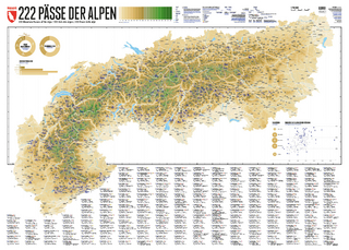
222 Mountain Passes of the Alps / 222 Cols des Alpes / 222 Passi …
Karte (gerollt) (2024)
Marmota Maps GmbH (Verlag)
CHF 84,90
Karte/Kartografie (2024)
Kompass-Karten (Verlag)
CHF 25,90
Und 20 besondere Wanderwege
Karte (gerollt) (2025)
Marmota Maps GmbH (Verlag)
CHF 84,90