


Ben Lawers and Schiehallion XT25
Seiten
2014
Harvey Map Services Ltd (Verlag)
978-1-85137-541-7 (ISBN)
Harvey Map Services Ltd (Verlag)
978-1-85137-541-7 (ISBN)
- Titel erscheint in neuer Auflage
- Artikel merken
Zu diesem Artikel existiert eine Nachauflage
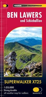
The map includes Ben Lawers, Schiehallion and the Tarmachan Ridge.
Detailed map for hillwalkers showing the hills between Loch Tay and Loch Rannoch.
Landscape and wildlife information from the National Trust for Scotland
Includes 16 Munros and 6 Corbetts.
Tough, light, durable and 100% waterproof
Opens directly to either side of the sheet
Easy to re-fold
Detailed map for hillwalkers showing the hills between Loch Tay and Loch Rannoch.
Landscape and wildlife information from the National Trust for Scotland
Includes 16 Munros and 6 Corbetts.
Tough, light, durable and 100% waterproof
Opens directly to either side of the sheet
Easy to re-fold
| Erscheint lt. Verlag | 1.9.2014 |
|---|---|
| Verlagsort | Perthshire |
| Sprache | englisch |
| Maße | 115 x 240 mm |
| Themenwelt | Sachbuch/Ratgeber ► Sport |
| Reisen ► Karten / Stadtpläne / Atlanten ► Europa | |
| ISBN-10 | 1-85137-541-4 / 1851375414 |
| ISBN-13 | 978-1-85137-541-7 / 9781851375417 |
| Zustand | Neuware |
| Informationen gemäß Produktsicherheitsverordnung (GPSR) | |
| Haben Sie eine Frage zum Produkt? |
Mehr entdecken
aus dem Bereich


aus dem Bereich
Karte (gefalzt) (2024)
Freytag-Berndt und ARTARIA (Verlag)
CHF 18,95
Georgien, Armenien, Aserbaidschan
Karte (gefalzt) (2025)
Freytag-Berndt und ARTARIA (Verlag)
CHF 24,90