


Philip's Red Books Argyll and the Isles
Leisure and Tourist Map
Seiten
2008
Philip's (Verlag)
978-0-540-09410-3 (ISBN)
Philip's (Verlag)
978-0-540-09410-3 (ISBN)
- Titel erscheint in neuer Auflage
- Artikel merken
Zu diesem Artikel existiert eine Nachauflage
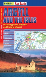
A leisure and tourist map of Argyll and the Isles, with places of interest clearly marked. Detailed coverage of the area's road network. Easy-to-read road mapping, ideal for journey route-planning. Great value for money at only GBP4.25.
This leisure and tourist map of Argyll and the Isles gives detailed coverage of the area's road network at a scale of 3.16 miles to 1 inch.The map shows places of tourist and historic interest, including castles, camping sites, country parks, galleries, gardens, golf courses, marinas, museums, nature trails, historic sites, sports venues, theatres, theme parks, wildlife parks and zoos. An index to principal places of interest is also featured.In a convenient folded format, this single-sided sheet map is ideally suited for both leisure and business use, whether by locals or visitors.
This leisure and tourist map of Argyll and the Isles gives detailed coverage of the area's road network at a scale of 3.16 miles to 1 inch.The map shows places of tourist and historic interest, including castles, camping sites, country parks, galleries, gardens, golf courses, marinas, museums, nature trails, historic sites, sports venues, theatres, theme parks, wildlife parks and zoos. An index to principal places of interest is also featured.In a convenient folded format, this single-sided sheet map is ideally suited for both leisure and business use, whether by locals or visitors.
| Erscheint lt. Verlag | 24.4.2008 |
|---|---|
| Verlagsort | London |
| Sprache | englisch |
| Maße | 140 x 240 mm |
| Gewicht | 90 g |
| Themenwelt | Reisen ► Bildbände |
| ISBN-10 | 0-540-09410-2 / 0540094102 |
| ISBN-13 | 978-0-540-09410-3 / 9780540094103 |
| Zustand | Neuware |
| Informationen gemäß Produktsicherheitsverordnung (GPSR) | |
| Haben Sie eine Frage zum Produkt? |
Mehr entdecken
aus dem Bereich


aus dem Bereich
Die Welt, wie Sie sie noch nie gesehen haben. XXL-Bildband
Buch | Hardcover (2025)
Vista Point (Verlag)
CHF 81,90
Lust am schönen Wohnen
Buch | Softcover (2025)
Aquensis Verlag
CHF 39,20