


Philip's Italy Road Map
Seiten
2008
|
Revised edition
Philip's (Verlag)
978-0-540-09327-4 (ISBN)
Philip's (Verlag)
978-0-540-09327-4 (ISBN)
- Titel erscheint in neuer Auflage
- Artikel merken
Zu diesem Artikel existiert eine Nachauflage
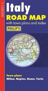
Shows the whole of Italy, including Sicily and Sardinia, at a standard scale of 1:1M (1 cm on the map is equal to 10 km on the ground). This map includes a comprehensive index, and detailed town plans of Milan, Naples, Rome and Turin, with tourist information clearly marked. The double-sided map has been prepared for long-distance travel.
Philip's "Italy Road Map" shows the whole of the country, including Sicily and Sardinia, at a standard scale of 1:1M (1 cm on the map is equal to 10 km on the ground). The map includes a comprehensive index, plus detailed town plans of Milan, Naples, Rome and Turin, with tourist information clearly marked. The double-sided map has been specially prepared for long-distance travel, picking out major routes and destinations in bold colours for easy journey planning and route-finding, and is a convenient size for use in a vehicle. The digital mapping gives excellent clarity, showing road networks in exceptional detail for this scale. High-quality travel information includes a wealth of useful detail marking car ferries, national parks, ski resorts, beaches, cathedrals, castles, ancient monuments, and many other places of interest. A comprehensive index includes all towns and villages shown on the map.
Philip's "Italy Road Map" shows the whole of the country, including Sicily and Sardinia, at a standard scale of 1:1M (1 cm on the map is equal to 10 km on the ground). The map includes a comprehensive index, plus detailed town plans of Milan, Naples, Rome and Turin, with tourist information clearly marked. The double-sided map has been specially prepared for long-distance travel, picking out major routes and destinations in bold colours for easy journey planning and route-finding, and is a convenient size for use in a vehicle. The digital mapping gives excellent clarity, showing road networks in exceptional detail for this scale. High-quality travel information includes a wealth of useful detail marking car ferries, national parks, ski resorts, beaches, cathedrals, castles, ancient monuments, and many other places of interest. A comprehensive index includes all towns and villages shown on the map.
| Erscheint lt. Verlag | 14.1.2008 |
|---|---|
| Reihe/Serie | Philip's Road Maps |
| Verlagsort | London |
| Sprache | englisch |
| Maße | 132 x 250 mm |
| Gewicht | 107 g |
| Themenwelt | Reisen ► Karten / Stadtpläne / Atlanten ► Europa |
| ISBN-10 | 0-540-09327-0 / 0540093270 |
| ISBN-13 | 978-0-540-09327-4 / 9780540093274 |
| Zustand | Neuware |
| Informationen gemäß Produktsicherheitsverordnung (GPSR) | |
| Haben Sie eine Frage zum Produkt? |
Mehr entdecken
aus dem Bereich


aus dem Bereich
Buch | Leporello (2025)
Kompass-Karten (Verlag)
CHF 21,90