


Lake District
Seiten
2019
|
2nd Revised edition
Harvey Map Services Ltd (Verlag)
978-1-85137-467-0 (ISBN)
Harvey Map Services Ltd (Verlag)
978-1-85137-467-0 (ISBN)
- Titel ist leider vergriffen;
keine Neuauflage - Artikel merken
Zu diesem Artikel existiert eine Nachauflage
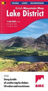
XT40 - A new generation of tough polyethylene maps. These maps are a leap forward in technical excellence. Tough, durable and 100% waterproof they are compact - not the great bulky package you get with a laminated map - and light to carry. This all weather British Mountain Map for climbers, hill wallkers, mountaineers and mountain bikers is published by HARVEY in co-operation with the British Mountaineering Council. The Lake District's famous mountains and fells on a single map, colour shading for easy identification of hills and valleys and detailed crag information for climbers. The reverse side of the map includes detailed 1:20000 enlargements of Scafell, Gable, Bowfell, Langdale Pikes and Pillar, a Geological map of the Lake District, mountain incident and first aid advice.
| Erscheint lt. Verlag | 30.9.2019 |
|---|---|
| Reihe/Serie | British Mountain Map |
| Zusatzinfo | 20 illustrations |
| Verlagsort | Perthshire |
| Sprache | englisch |
| Maße | 125 x 235 mm |
| Themenwelt | Reisen ► Karten / Stadtpläne / Atlanten ► Europa |
| ISBN-10 | 1-85137-467-1 / 1851374671 |
| ISBN-13 | 978-1-85137-467-0 / 9781851374670 |
| Zustand | Neuware |
| Informationen gemäß Produktsicherheitsverordnung (GPSR) | |
| Haben Sie eine Frage zum Produkt? |
Mehr entdecken
aus dem Bereich


aus dem Bereich
Karte (gefalzt) (2024)
Freytag-Berndt und ARTARIA (Verlag)
CHF 18,95
Georgien, Armenien, Aserbaidschan
Karte (gefalzt) (2025)
Freytag-Berndt und ARTARIA (Verlag)
CHF 24,90