


AA Traveller’s Atlas France 2026
Seiten
2025
|
3rd New edition
Automobile Association (Verlag)
978-0-7495-8438-2 (ISBN)
Automobile Association (Verlag)
978-0-7495-8438-2 (ISBN)
Zu diesem Artikel existiert eine Nachauflage
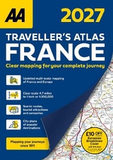
Fully updated for 2026, this A4 format road atlas of France provides clear mapping at 4.7 miles to 1 inch.
Featuring detailed city maps of Paris, Lille and Lyon,16 pages of overview mapping of Europe, France and scenic routes, campsites and tourist attractions and £10 off AA European Breakdown Cover promotion.
This specialist A4 road atlas is designed for the British motorist in France. With the mapping scale at 4.7 miles to 1 inch, coverage includes 28 city centre plans to help you find your way in and around busy centres.
The road mapping clearly shows places of interest and important features to help drivers find their way more easily and explore France in greater detail. The mapping includes 6 district (environs) maps covering Brest, Strasbourg, Marseille, Paris, Nice, Monaco and Nimes, Avignon and Orange.
| Erscheinungsdatum | 20.05.2025 |
|---|---|
| Verlagsort | Basingstoke |
| Sprache | englisch |
| Maße | 210 x 295 mm |
| Themenwelt | Reisen ► Karten / Stadtpläne / Atlanten ► Europa |
| Reisen ► Karten / Stadtpläne / Atlanten ► Welt / Arktis / Antarktis | |
| ISBN-10 | 0-7495-8438-6 / 0749584386 |
| ISBN-13 | 978-0-7495-8438-2 / 9780749584382 |
| Zustand | Neuware |
| Informationen gemäß Produktsicherheitsverordnung (GPSR) | |
| Haben Sie eine Frage zum Produkt? |
Mehr entdecken
aus dem Bereich


aus dem Bereich
Buch | Leporello (2025)
Kompass-Karten (Verlag)
CHF 21,90