


Philip's Street Atlas Birmingham and West Midlands
Seiten
2006
Philip's (Verlag)
978-0-540-08836-2 (ISBN)
Philip's (Verlag)
978-0-540-08836-2 (ISBN)
- Titel erscheint in neuer Auflage
- Artikel merken
Zu diesem Artikel existiert eine Nachauflage
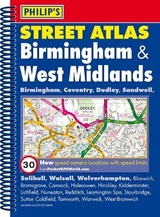
A brand new edition of this successful colour atlas of Birmingham & West Midlands, giving the most comprehensive and detailed coverage of the region. No other atlas names every street in Birmingham & West Midlands.The mapping is produced by the Ordnance Survey to our specification and gives the user complete coverage of all urban and rural areas. The mapping is at a standard scale of 3 1/2 inches to 1 mile, 2 1/2 inches to 1 mile in the pocket edition, and is complete with postcode boundaries.The atlas is ideally suited for both business and leisure use. There is a route-planning map and an administrative and postcode map at the front of the atlas. The main maps show every named road, street and lane clearly with through-routes highlighted. School locations are marked and emergency services, hospitals, police stations, car parks and rail and bus station locations are all featured. There is a comprehensive index of street names and postcodes that includes schools, industrial estates, hospitals, sports centres, etc, which are highlighted in colour.Main map scale: 3 1/2 inches to 1 mile
| Verlagsort | London |
|---|---|
| Sprache | englisch |
| Maße | 200 x 268 mm |
| Gewicht | 665 g |
| Themenwelt | Reisen ► Karten / Stadtpläne / Atlanten ► Europa |
| ISBN-10 | 0-540-08836-6 / 0540088366 |
| ISBN-13 | 978-0-540-08836-2 / 9780540088362 |
| Zustand | Neuware |
| Informationen gemäß Produktsicherheitsverordnung (GPSR) | |
| Haben Sie eine Frage zum Produkt? |
Mehr entdecken
aus dem Bereich


aus dem Bereich
Buch | Leporello (2025)
Kompass-Karten (Verlag)
CHF 21,90