Walking Rum and the Small Isles
Cicerone Press (Verlag)
978-1-78631-217-4 (ISBN)
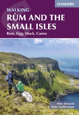
Guidebook to 25 coastal and mountain walks on the Small Isles of Rum, Eigg, Muck and Canna, suitable for a range of abilities. Explore this wild and rugged archipelago off Scotland’s west coast, where volcanic peaks, dramatic cliffs and quiet shorelines offer some of the Hebrides’ most rewarding walking. Highlights include the towering Cuillin of Rum, the pitchstone ridge of An Sgùrr on Eigg, Canna’s spectacular sea cliffs and Muck’s fascinating coastline.
The routes range from short rambles to longer treks, including a challenging three-day, 41km (25 mile) circuit around the coast of Rum. Walks vary from 3–41km (2–25 miles) and can be completed in 1 to 3 days, depending on the route. Many walks are circular, while others link key island features or viewpoints. The varied terrain includes rough mountain paths, moorland, open pasture and coastal tracks.
1:50,000 OS mapping included for each walk
Step-by-step descriptions with distance, ascent, time, difficulty and terrain
Includes transport, accommodation and trip-planning advice
Background information on geology, wildlife and local history
GPX files available to download
Peter Edwards lives in Rhenigidale on the Isle of Harris with his wife, Fiona and their Labradors, Mara and Sandie. He is usually happiest when out walking. Katie Featherstone is a freelance writer and the author of several guidebooks. She writes about hiking, history and slow, sustainable travel. While Peter lives up in the Western Isles, Katie inhabits Port Ellen – Islay – in the Hebrides’ far south; the spectacular Small Isles lie scattered between them, conveniently accessed by neither party, but impossible to resist.
Route summary table Introduction When to go Getting there Maps and route-finding Access Safety and emergencies What to take Using this guidebook Rùm Walk 1: A round of the Rùm Cuillin Walk 2: The Dibidil Horseshoe Walk 3: Askival and Hallival from Kinloch Walk 4: Hallival and Barkeval from Kinloch Walk 5: Around the coast of Rùm Day 1: Kinloch to Dibidil Day 2: Dibidil to Guirdil Day 3: Guirdil to Kinloch Walk 6: Kinloch to Guirdil Walk 7: The Guirdil Horseshoe Walk 8: Orval and Àrd Nev Walk 9: Kinloch to Harris Bay Walk 10: Kinloch to Kilmory Bay Walk 11: Port na Caranean Eigg Walk 12: Uamh Fhraing and Uamh Chràbhaichd Walk 13: Grulin from Galmisdale Walk 14: An Sgùrr and Grulin Walk 15: Beannan Breaca and the south-west Walk 16: The Beinn Bhuidhe plateau from Galmisdale Walk 17: Sgorr an Fhàraidh Walk 18: Camas Sgiotaig and the north-west coast Walk 19: Around the north-east coast of Eigg Canna and Sanday Walk 20: A’ Chill, Compass Hill and Black Sand Beach Walk 21: Around Canna Walk 22: Around Sanday Muck Walk 23: Around Muck Walk 24: Beinn Airein and Camas Mòr Walk 25: Caisteal an Dùin Bhàin and the far south coast Appendix A: Useful websites Appendix B : Further reading
| Erscheinungsdatum | 17.09.2025 |
|---|---|
| Reihe/Serie | Cicerone guidebooks |
| Zusatzinfo | 100 colour photos and 30 OS map extracts |
| Verlagsort | Kendal |
| Sprache | englisch |
| Maße | 116 x 172 mm |
| Gewicht | 210 g |
| Themenwelt | Sachbuch/Ratgeber ► Sport |
| Reiseführer ► Europa ► Großbritannien | |
| Reisen ► Sport- / Aktivreisen ► Europa | |
| ISBN-10 | 1-78631-217-4 / 1786312174 |
| ISBN-13 | 978-1-78631-217-4 / 9781786312174 |
| Zustand | Neuware |
| Informationen gemäß Produktsicherheitsverordnung (GPSR) | |
| Haben Sie eine Frage zum Produkt? |
aus dem Bereich