


World Satellite, Laminated
Wall Maps World
Seiten
2012
|
2008th ed.
National Geographic Maps (Verlag)
978-0-7922-8302-7 (ISBN)
National Geographic Maps (Verlag)
978-0-7922-8302-7 (ISBN)
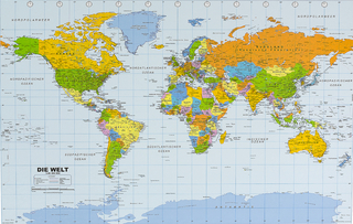
The most accurate map of the Earth's surface ever produced from satellite data. This computer-generated composite map draws from more than 500 images to give one-kilometre detail and consistent representation of natural colours. Scale: 1:38,931,000. Laminated. 109 x 76.2 cm.
| Erscheint lt. Verlag | 2.8.2012 |
|---|---|
| Verlagsort | Evergreen |
| Sprache | englisch |
| Maße | 56 x 820 mm |
| Gewicht | 284 g |
| Themenwelt | Reisen ► Karten / Stadtpläne / Atlanten ► Welt / Arktis / Antarktis |
| ISBN-10 | 0-7922-8302-3 / 0792283023 |
| ISBN-13 | 978-0-7922-8302-7 / 9780792283027 |
| Zustand | Neuware |
| Informationen gemäß Produktsicherheitsverordnung (GPSR) | |
| Haben Sie eine Frage zum Produkt? |
Mehr entdecken
aus dem Bereich
aus dem Bereich
Karte (plano) (2025)
INTERKART Landkarten & Globen (Verlag)
CHF 15,90