


Map of France 2021
Folded Road Map
Seiten
2020
|
New edition
Collins (Verlag)
978-0-00-837435-8 (ISBN)
Collins (Verlag)
978-0-00-837435-8 (ISBN)
- Titel erscheint in neuer Auflage
- Artikel merken
Zu diesem Artikel existiert eine Nachauflage
Explore new places with dependable maps from Collins.
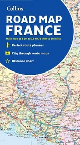
A fully revised and updated colour road map of France at 18 miles to 1 inch / 11km to 1cm (1:1,120,000). The map shows individual department by name. All cities, towns, roads, European route numbers, motorways and toll motorways are clearly shown, making it the ideal map for planning and route-finding.
The map shows the road network in detail for easy route planning. With its political colouring of departments, it is ideal for reference and business users also.
Main features
• Fully revised and updated
Clear, detailed road network
Through-route maps of Paris, Lyon, Marseille, Strasbourg, and Toulouse
Distance chart giving distances in kilometres between main towns
Key to department names and numbers, and list of regions
Internet links to further information
Full Index to place names
Map key in English, French and German
Area of coverage
Covers the whole of France from the Belgian and German borders in the north to the Spanish border in the south, and from the Brest Peninsula in the west to the Italian and Swiss borders in the east. Also includes the island of Corsica.
Explore the world through accurate and up-to-date mapping.
| Erscheint lt. Verlag | 30.6.2020 |
|---|---|
| Reihe/Serie | Collins Road Atlas |
| Verlagsort | London |
| Sprache | englisch |
| Maße | 140 x 250 mm |
| Gewicht | 120 g |
| Themenwelt | Reisen ► Karten / Stadtpläne / Atlanten ► Europa |
| Reisen ► Karten / Stadtpläne / Atlanten ► Welt / Arktis / Antarktis | |
| ISBN-10 | 0-00-837435-X / 000837435X |
| ISBN-13 | 978-0-00-837435-8 / 9780008374358 |
| Zustand | Neuware |
| Informationen gemäß Produktsicherheitsverordnung (GPSR) | |
| Haben Sie eine Frage zum Produkt? |
Mehr entdecken
aus dem Bereich


aus dem Bereich
Karte (gefalzt) (2024)
Freytag-Berndt und ARTARIA (Verlag)
CHF 18,95
markierte Wanderwege, Hütten, Radrouten
Karte (gefalzt) (2023)
Kompass-Karten (Verlag)
CHF 26,90