


Queensland State & Suburban Map 470 27th ed
Seiten
2018
|
Twenty-seventh Edition
UBD Gregory's (Verlag)
978-0-7319-3146-0 (ISBN)
UBD Gregory's (Verlag)
978-0-7319-3146-0 (ISBN)
- Titel erscheint in neuer Auflage
- Artikel merken
Zu diesem Artikel existiert eine Nachauflage
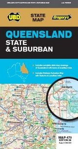
The latest edition of the popular Queensland State and Suburban Map is an essential tool for those travelling around Queensland and the Brisbane area. It includes:
State map of Queensland plus an index to the towns towns and localities featured.
Suburban map coverage of Brisbane city & surrounds north to Caboolture, south to Cedar Vale, along the coast from Sandstone Point in the north to Ormiston and east to Brassall.
An index to the towns and localities featured.
| Erscheint lt. Verlag | 1.3.2018 |
|---|---|
| Reihe/Serie | State Map |
| Zusatzinfo | NA |
| Sprache | englisch |
| Maße | 920 x 690 mm |
| Themenwelt | Reisen ► Karten / Stadtpläne / Atlanten |
| ISBN-10 | 0-7319-3146-7 / 0731931467 |
| ISBN-13 | 978-0-7319-3146-0 / 9780731931460 |
| Zustand | Neuware |
| Informationen gemäß Produktsicherheitsverordnung (GPSR) | |
| Haben Sie eine Frage zum Produkt? |
Mehr entdecken
aus dem Bereich


aus dem Bereich
Wanderkarte Nr. 50 des Eifelvereins
Karte (gefalzt) (2025)
Eifelverein (Verlag)
CHF 19,90
Karte/Kartografie (2024)
Kompass-Karten (Verlag)
CHF 25,90
Hildesheim – Celle – Schaumburger Land – Weserbergland – Mittelweser
Karte/Kartografie (2024)
Esterbauer (Verlag)
CHF 14,90