


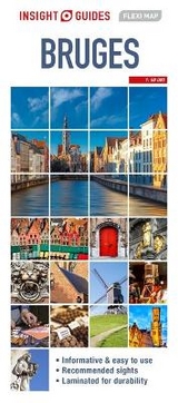
Insight Flexi Map: Bruges
Seiten
2015
|
4th Revised edition
Insight Guides (Verlag)
9781780058139 (ISBN)
Insight Guides (Verlag)
9781780058139 (ISBN)
- Titel erscheint in neuer Auflage
- Artikel merken
Zu diesem Artikel existiert eine Nachauflage
Includes detailed descriptions and photographs of Bruges. This book also offers helpful information on getting around, tipping, opening times, public holidays, emergency telephone numbers and much more. It is divided into different categories, such as Points of Interest, Public Buildings and Hotels, to make locating places as easy as possible.
Flexi Map Bruges is much more than just a laminated map. The tourist information section includes detailed descriptions and some stunning photographs of a carefully selected number of recommended sights, these sights are linked to the mapping by easy to find numbered markers. There is also an abundance of helpful information on getting around, tipping, opening times, public holidays, emergency telephone numbers and much more.
The comprehensive index has been divided into different categories to make locating places as easy as possible. The laminated, tear-resistant finish is tough, weatherproof and can be written on using a non-permanent marker.
The main map shows the city at a scale of 1:7 000 (1cm = 0.07km) and highlights numerous places of interest such as public buildings, hotels, embassies and parks. A city plan of Ghent is also included at a scale of 1:16 000 (1cm = 0.16km).
The reverse side depicts Flanders at a scale of 1:400 000 (1cm = 4km) - ideal for exploring slightly further afield.
| Erscheint lt. Verlag | 1.4.2015 |
|---|---|
| Reihe/Serie | Insight Guides Flexi Maps |
| Verlagsort | London |
| Sprache | englisch |
| Themenwelt | Reisen ► Karten / Stadtpläne / Atlanten ► Europa |
| ISBN-13 | 9781780058139 / 9781780058139 |
| Zustand | Neuware |
| Informationen gemäß Produktsicherheitsverordnung (GPSR) | |
| Haben Sie eine Frage zum Produkt? |
Mehr entdecken
aus dem Bereich


aus dem Bereich
Narvik
Karte (gefalzt) (2023)
Freytag-Berndt und ARTARIA (Verlag)
CHF 21,90
Karte (gefalzt) (2024)
Freytag-Berndt und ARTARIA (Verlag)
CHF 18,95