


Edinburgh Illustrated Map
1996
|
3rd Revised edition
Collins (Verlag)
978-0-7028-3015-0 (ISBN)
Collins (Verlag)
978-0-7028-3015-0 (ISBN)
- Titel erscheint in neuer Auflage
- Artikel merken
Zu diesem Artikel existiert eine Nachauflage
Coloured mapping and masses of detail combine to make this map a practical guide to Edinburgh. The front of the map covers the city from the Scottish National Gallery of Modern Art to the Palace of Holyrood. The reverse has a street index, with specific parts of Edinburgh illustrated.
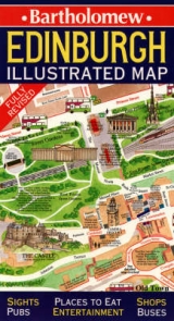
Coloured mapping and masses of detail combine to make this map a practical guide to the city of Edinburgh and a charming and unusual souvenir. The front of the map covers the city from the Scottish National Gallery of Modern Art to the Palace of Holyrood, taking in all the main sights and tourist attractions - all the most important buildings are individually painted. There are also hundreds of restaurants, shops, bars, pubs, hotels, theatres and cinemas, plus lots of interesting little anecdotes and stories. The map provides a key to all the central Edinburgh bus routes, with route numbers shown in the windows of the buses at all major intersections. The reverse of the map has a comprehensive street index and also illustrates, in detail, specific parts of Edinburgh noted for their amenities. These include The Royal Mile and the Castle, Stockbridge, Dean Village and the Royal Circus. Other interesting features of the map are itineraries to make the most of the city, and nearby villages worth a visit.
Coloured mapping and masses of detail combine to make this map a practical guide to the city of Edinburgh and a charming and unusual souvenir. The front of the map covers the city from the Scottish National Gallery of Modern Art to the Palace of Holyrood, taking in all the main sights and tourist attractions - all the most important buildings are individually painted. There are also hundreds of restaurants, shops, bars, pubs, hotels, theatres and cinemas, plus lots of interesting little anecdotes and stories. The map provides a key to all the central Edinburgh bus routes, with route numbers shown in the windows of the buses at all major intersections. The reverse of the map has a comprehensive street index and also illustrates, in detail, specific parts of Edinburgh noted for their amenities. These include The Royal Mile and the Castle, Stockbridge, Dean Village and the Royal Circus. Other interesting features of the map are itineraries to make the most of the city, and nearby villages worth a visit.
| Erscheint lt. Verlag | 2.5.1996 |
|---|---|
| Zusatzinfo | index |
| Verlagsort | London |
| Sprache | englisch |
| Maße | 114 x 206 mm |
| Gewicht | 65 g |
| Themenwelt | Reisen ► Karten / Stadtpläne / Atlanten ► Europa |
| ISBN-10 | 0-7028-3015-1 / 0702830151 |
| ISBN-13 | 978-0-7028-3015-0 / 9780702830150 |
| Zustand | Neuware |
| Informationen gemäß Produktsicherheitsverordnung (GPSR) | |
| Haben Sie eine Frage zum Produkt? |
Mehr entdecken
aus dem Bereich


aus dem Bereich
Karte (gefalzt) (2024)
Freytag-Berndt und ARTARIA (Verlag)
CHF 18,95
markierte Wanderwege, Hütten, Radrouten
Karte (gefalzt) (2023)
Kompass-Karten (Verlag)
CHF 26,90
Karte (gefalzt) (2025)
Kompass-Karten (Verlag)
CHF 31,90