


AA Road Atlas Europe
Seiten
2013
|
14
Automobile Association (Verlag)
978-0-7495-7526-7 (ISBN)
Automobile Association (Verlag)
978-0-7495-7526-7 (ISBN)
- Titel erscheint in neuer Auflage
- Artikel merken
Zu diesem Artikel existiert eine Nachauflage
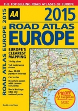
Fully revised and updated for 2014, this specialist A4 road atlas designed for the British motorist in Europe provides multiscale mapping of 46 countries. The atlas includes information on national speed limits, emergency telephone numbers and road distances together with national parks and many other places of interest. Toll-free motorways are shown, car ferries, mountain passes with caravan suitability and World Heritage sites and national parks. 33 city plans are also included.
AA Publishing is the UK's biggest travel publisher and one of the top ten worldwide.
| Erscheint lt. Verlag | 30.11.2013 |
|---|---|
| Zusatzinfo | Scale: 14.2 miles to 1 inch |
| Verlagsort | Basingstoke |
| Sprache | englisch |
| Maße | 220 x 297 mm |
| Themenwelt | Reisen ► Karten / Stadtpläne / Atlanten ► Europa |
| ISBN-10 | 0-7495-7526-3 / 0749575263 |
| ISBN-13 | 978-0-7495-7526-7 / 9780749575267 |
| Zustand | Neuware |
| Informationen gemäß Produktsicherheitsverordnung (GPSR) | |
| Haben Sie eine Frage zum Produkt? |
Mehr entdecken
aus dem Bereich


aus dem Bereich
Buch | Leporello (2025)
Kompass-Karten (Verlag)
CHF 21,90