


Insight Travel Maps: Spain & Portugal
Seiten
2012
|
4th Revised edition
Insight Maps (Verlag)
9781780054407 (ISBN)
Insight Maps (Verlag)
9781780054407 (ISBN)
- Titel erscheint in neuer Auflage
- Artikel merken
Zu diesem Artikel existiert eine Nachauflage
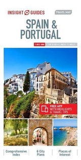
Presents a double-sided, indexed road map at 1:800 000 showing northern Spain & Portugal on one side and southern Spain & Portugal on the reverse, with generous overlap in the middle. This book includes detailed city plans of Barcelona, Bilbao, Madrid, Seville, Valencia and Lisbon, each with its own index listing.
Travel Map Spain & Portugal is a double-sided, indexed road map at
1 : 800 000 showing northern Spain & Portugal on one side and southern Spain & Portugal on the reverse, with generous overlap in the middle. Detailed city plans of Barcelona, Bilbao, Madrid, Seville, Valencia and Lisbon are included, each with its own index listing. Additional maps cover the Balearic and Canary Islands, the Azores and Madeira.
Places of interest including museums, monuments and religious sites are listed and accompanied by a wide range of pictorial symbols for instant recognition, these symbols have been colour coded by category.
In addition to the road and rail networks, airports, major ports and ferry routes, this map provides a detailed picture of the topography through the use of relief shading. National parks, valleys, mountain ranges with peak heights, nature reserves, trekking areas and The Way of Saint James (Camino de Santiago - Camino Francés) are clearly indicated.
This map has handy distance indicators in the margin and shows intermediate driving distances on main roads. The extensive legend is shown in 4 languages.
| Erscheint lt. Verlag | 1.10.2012 |
|---|---|
| Reihe/Serie | Insight Guides Travel Maps |
| Sprache | englisch |
| Themenwelt | Reisen ► Karten / Stadtpläne / Atlanten ► Europa |
| ISBN-13 | 9781780054407 / 9781780054407 |
| Zustand | Neuware |
| Informationen gemäß Produktsicherheitsverordnung (GPSR) | |
| Haben Sie eine Frage zum Produkt? |
Mehr entdecken
aus dem Bereich


aus dem Bereich
Narvik
Karte (gefalzt) (2023)
Freytag-Berndt und ARTARIA (Verlag)
CHF 21,90
Karte (gefalzt) (2024)
Freytag-Berndt und ARTARIA (Verlag)
CHF 18,95