


AA Easy Read Britain
2010
|
11th Revised edition
Automobile Association (Verlag)
978-0-7495-6618-0 (ISBN)
Automobile Association (Verlag)
978-0-7495-6618-0 (ISBN)
- Titel erscheint in neuer Auflage
- Artikel merken
Zu diesem Artikel existiert eine Nachauflage
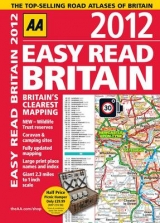
This A4 format atlas provides giant scale mapping, at 2.3 miles to 1 inch, and type throughout making it very easy to use. Given away with the atlas is a free magnetic tax disc holder and 10 money saving vouchers offering discounts on AA products and services. Each page has been titled with its geographical location so you can turn to the page you need more easily. Static speed camera locations with speed limits are pinpointed. Wide minor roads, National Trust, English and World Heritage sites, crematorium and other hard-to-find places are also shown. There is also a full-colour admin map showing all the latest unitary authority areas, route-planning map and journey planning section. The paper in this atlas is produced from environmentally sustainable resources.
| Erscheint lt. Verlag | 1.7.2010 |
|---|---|
| Verlagsort | Basingstoke |
| Sprache | englisch |
| Themenwelt | Reisen ► Karten / Stadtpläne / Atlanten ► Europa |
| ISBN-10 | 0-7495-6618-3 / 0749566183 |
| ISBN-13 | 978-0-7495-6618-0 / 9780749566180 |
| Zustand | Neuware |
| Informationen gemäß Produktsicherheitsverordnung (GPSR) | |
| Haben Sie eine Frage zum Produkt? |
Mehr entdecken
aus dem Bereich


aus dem Bereich
Buch | Leporello (2025)
Kompass-Karten (Verlag)
CHF 21,90