


Big London Street Atlas
Seiten
1999
|
Revised edition
Collins (Verlag)
978-0-00-448834-9 (ISBN)
Collins (Verlag)
978-0-00-448834-9 (ISBN)
- Titel erscheint in neuer Auflage
- Artikel merken
Zu diesem Artikel existiert eine Nachauflage
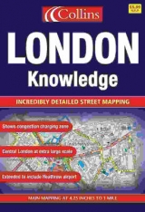
1:15,000 4.2 inches to 1 mile Central London at 8.4 inches to 1 mile (1:15000) This atlas is ideal for the driver in central london. The large scale and high level of detail make it an essential purchase.
MAIN FEATURES
• Large scale full colour mapping
• Extensive area of coverage
• Extra large scale central London section
• Large format
• Includes London & M25 route planning maps
INCLUDES
• Index to places of interest
• Full index to street names
• CIear colour-coded roads and buildings
AREA OF COVERAGE
Extends from Heathrow in the west to Barking in the east, and from Edmonton in the north to Beckenham in the south.
WHO THE PRODUCT IS AIMED AT
Especially useful for businesses and drivers.
OTHER PRODUCTS IN THE SERIES
Collins publish a wide range of London mapping in a variety of scales and formats.
| Erscheint lt. Verlag | 7.6.1999 |
|---|---|
| Zusatzinfo | Index |
| Verlagsort | London |
| Sprache | englisch |
| Maße | 260 x 380 mm |
| Gewicht | 548 g |
| Themenwelt | Reisen ► Karten / Stadtpläne / Atlanten ► Europa |
| ISBN-10 | 0-00-448834-2 / 0004488342 |
| ISBN-13 | 978-0-00-448834-9 / 9780004488349 |
| Zustand | Neuware |
| Informationen gemäß Produktsicherheitsverordnung (GPSR) | |
| Haben Sie eine Frage zum Produkt? |
Mehr entdecken
aus dem Bereich


aus dem Bereich
Buch | Leporello (2025)
Kompass-Karten (Verlag)
CHF 21,90