


Glovebox Atlas Britain
Seiten
2009
|
12th Revised edition
Automobile Association (Verlag)
978-0-7495-6315-8 (ISBN)
Automobile Association (Verlag)
978-0-7495-6315-8 (ISBN)
- Titel erscheint in neuer Auflage
- Artikel merken
Zu diesem Artikel existiert eine Nachauflage
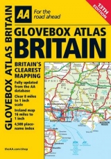
An atlas that includes a county, administrative area map of Britain and a comprehensive 4,500 place name index. It offers information on road map symbols, key to map page and mileage charts. It is suitable for those who are traveling through Britain and Ireland.
This handy atlas easily fits in the glove box of your car, perfect for quick referencing on the move. Fully updated from the AA mapping database, the atlas includes a county, administrative area map of Britain and a comprehensive 4,500 place name index. Also including information on road map symbols, key to map page and mileage charts, this is the perfect glove box companion for traveling through Britain and Ireland.
This handy atlas easily fits in the glove box of your car, perfect for quick referencing on the move. Fully updated from the AA mapping database, the atlas includes a county, administrative area map of Britain and a comprehensive 4,500 place name index. Also including information on road map symbols, key to map page and mileage charts, this is the perfect glove box companion for traveling through Britain and Ireland.
| Erscheint lt. Verlag | 21.9.2009 |
|---|---|
| Reihe/Serie | AA Atlases and Maps |
| Verlagsort | Basingstoke |
| Sprache | englisch |
| Maße | 152 x 210 mm |
| Themenwelt | Reisen ► Karten / Stadtpläne / Atlanten ► Europa |
| ISBN-10 | 0-7495-6315-X / 074956315X |
| ISBN-13 | 978-0-7495-6315-8 / 9780749563158 |
| Zustand | Neuware |
| Informationen gemäß Produktsicherheitsverordnung (GPSR) | |
| Haben Sie eine Frage zum Produkt? |
Mehr entdecken
aus dem Bereich


aus dem Bereich
Buch | Leporello (2025)
Kompass-Karten (Verlag)
CHF 21,90