


3000 Plus - the Original Munro Map
The Original Munro Map
2009
|
6th New edition
Gordon D.Henderson (Verlag)
978-0-9527381-2-1 (ISBN)
Gordon D.Henderson (Verlag)
978-0-9527381-2-1 (ISBN)
- Titel nicht im Sortiment
- Artikel merken
A full-colour map of Scotland's 3000ft mountains that shows the location of 511 summits. It helps outdoor enthusiasts to plan their next ascent and track their progress. It depicts all 511 Munro Mountains and Tops. It includes mountain profiles which provide a recognisable silhouette of the mountain ranges and their relative positions.
"3000 PLUS - The Original Munro Map", is the most comprehensive, full-colour map of Scotland's 3000ft mountains available today, clearly showing the location of all 511 summits - an invaluable tool for outdoor enthusiasts to plan their next ascent and track their progress. First published in 1980, this is the 6th edition, fully revised, updated and redesigned. It depicts all 511 Munro Mountains and Tops, including the 90 peaks - such as the recently reclassified summits of Beinn a' Chroin near Balquhidder - demoted from Munro status since the first tables of 1891. New to this edition of "3000 PLUS" is the inclusion of mountain profiles which provide an instantly recognisable silhouette of the mountain ranges and their relative positions. Also new are layer tints to highlight the relief of Scotland's rugged mountain landscape and the geographical distribution of all summits. Also, for the first time, this edition comes with a glossy protective card cover.
Further information includes road, rail and sea routes; hostels and bothies; Outdoor Training Centres; relevant OS 1:50,000 Landranger maps; and, a simple co-ordinate reference system to relate the Munros to the map and vice versa and information about The Mountain Rescue Committee of Scotland. This title is fully revised, updated and redesigned. It features: most comprehensive map of the Munros available; definitive list of all summits past and present since 1891; mountain profiles; and, relief by layer colouring. It is designed by a hillwalker for hillwalkers. It is presented in glossy protective card cover.
| Erscheint lt. Verlag | 15.3.2009 |
|---|---|
| Zusatzinfo | full colour mapping |
| Verlagsort | Aberdeen |
| Sprache | englisch |
| Maße | 135 x 242 mm |
| Themenwelt | Sachbuch/Ratgeber ► Sport |
| Reisen ► Karten / Stadtpläne / Atlanten | |
| ISBN-10 | 0-9527381-2-0 / 0952738120 |
| ISBN-13 | 978-0-9527381-2-1 / 9780952738121 |
| Zustand | Neuware |
| Informationen gemäß Produktsicherheitsverordnung (GPSR) | |
| Haben Sie eine Frage zum Produkt? |
Mehr entdecken
aus dem Bereich
aus dem Bereich
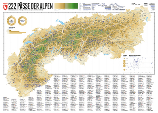
222 Mountain Passes of the Alps / 222 Cols des Alpes / 222 Passi …
Karte (gerollt) (2024)
Marmota Maps GmbH (Verlag)
CHF 84,90
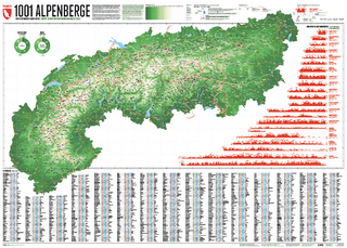
Und 20 besondere Wanderwege
Karte (gerollt) (2025)
Marmota Maps GmbH (Verlag)
CHF 84,90