


Falkland Islands Explorer
Visitors Map of the Falklands Islands Including Stanley Town Plan
2007
Ocean Explorer Maps (Verlag)
978-0-9543717-4-6 (ISBN)
Ocean Explorer Maps (Verlag)
978-0-9543717-4-6 (ISBN)
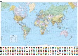
Part of the "Ocean Explorer" series, this work covers the Falkland Islands region. It provides a detailed map of the islands with key areas identified. It presents information of the areas wildlife, geography and history, along with providing a town plan to Stanley.
A fold-out visitor's map (scale 1 : 365 000), that measures approximately 75 x 46 cm (W x H) when unfolded. Produced in the same format as the previous maps in the series, one side provides a detailed map of the islands with key areas identified, while the other side presents information of the areas wildlife, geography and history, along with providing a town plan to Stanley.
A fold-out visitor's map (scale 1 : 365 000), that measures approximately 75 x 46 cm (W x H) when unfolded. Produced in the same format as the previous maps in the series, one side provides a detailed map of the islands with key areas identified, while the other side presents information of the areas wildlife, geography and history, along with providing a town plan to Stanley.
| Erscheint lt. Verlag | 31.12.2007 |
|---|---|
| Reihe/Serie | Ocean Explorer Maps |
| Zusatzinfo | colour photos, b/w illustrations, colour maps, scale: 1 : 365 000; dimensions: 75 × 46 cm |
| Verlagsort | Chichester |
| Sprache | englisch |
| Maße | 125 x 230 mm |
| Themenwelt | Reisen ► Karten / Stadtpläne / Atlanten ► Welt / Arktis / Antarktis |
| Naturwissenschaften ► Geowissenschaften ► Geografie / Kartografie | |
| ISBN-10 | 0-9543717-4-7 / 0954371747 |
| ISBN-13 | 978-0-9543717-4-6 / 9780954371746 |
| Zustand | Neuware |
| Informationen gemäß Produktsicherheitsverordnung (GPSR) | |
| Haben Sie eine Frage zum Produkt? |
Mehr entdecken
aus dem Bereich
aus dem Bereich
Format 138 x 98 cm, gerollt in umweltfreundlicher grüner Papphülse
Karte (gerollt) (2025)
druckbunt Verlag GmbH
CHF 27,90
Karte (gerollt) (2025)
Kümmerly+Frey (Verlag)
CHF 26,90