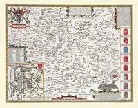
John Speed Map of Leicestershire 1611
20" x 16" Photographic Print of the County Leicestershire - England
2010
Historical Images Ltd (Verlag)
978-1-84491-028-1 (ISBN)
Historical Images Ltd (Verlag)
978-1-84491-028-1 (ISBN)
- Keine Verlagsinformationen verfügbar
- Artikel merken
Map of Leicestershire originally published in 1611 by John Speed, digitally re-mastered from an antique original and printed onto photographic quality media. Supplied flat in a polypropylene sleeve and back board, the 20" x 16" (approx. 508 mm x 406 mm) print can be removed from the protective sleeve for framing or retained in the sleeve.
There is a plan of Old Leicester in the bottom left hand corner, and a short history of the county in the top left. Depicted are ten coats of arms, including those of the Earls of Leicester, such as Simon de Montfort, and the Royal coat of arms. On the map "Kinge Richard's Feild" (the site of the Battle of Bosworth) is marked, as well as Bradgate Park, where Lady Jane Grey, the Nine Days Queen, was born.
There is a plan of Old Leicester in the bottom left hand corner, and a short history of the county in the top left. Depicted are ten coats of arms, including those of the Earls of Leicester, such as Simon de Montfort, and the Royal coat of arms. On the map "Kinge Richard's Feild" (the site of the Battle of Bosworth) is marked, as well as Bradgate Park, where Lady Jane Grey, the Nine Days Queen, was born.
| Erscheint lt. Verlag | 5.2.2010 |
|---|---|
| Verlagsort | Truro |
| Sprache | englisch |
| Themenwelt | Sachbuch/Ratgeber ► Geschichte / Politik ► Regional- / Landesgeschichte |
| Geisteswissenschaften ► Geschichte ► Hilfswissenschaften | |
| ISBN-10 | 1-84491-028-8 / 1844910288 |
| ISBN-13 | 978-1-84491-028-1 / 9781844910281 |
| Zustand | Neuware |
| Informationen gemäß Produktsicherheitsverordnung (GPSR) | |
| Haben Sie eine Frage zum Produkt? |