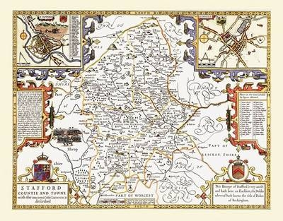
John Speed Map of Staffordshire 1611
20" x 16" Photographic Print of the County of Staffordshire - England
2010
Historical Images Ltd (Verlag)
978-1-84491-008-3 (ISBN)
Historical Images Ltd (Verlag)
978-1-84491-008-3 (ISBN)
- Keine Verlagsinformationen verfügbar
- Artikel merken
Map of Staffordshire originally published in 1611 by John Speed, digitally re-mastered from an antique original and printed onto photographic quality media. Supplied in a tube - Print Size 20" x 16"
There are bird's eye views of the cities of Stafford and Lichfield in the top corners, each with a legend. An illustration and description of a battle that occurred in 1459 is also shown, to the left of the map. Depicted on this map are the woodlands that made up a lot of the county before the growth of the West Midlands, as well as estates and deer parks, castles and hills, all of which have been named. Other interesting details such as the "Three Shires Stones" in the north of the county, and "The water goeth underground" beside a river close to the Derbyshire border really complement this lovely map, and make it a wonderful gift for anyone from this county.
There are bird's eye views of the cities of Stafford and Lichfield in the top corners, each with a legend. An illustration and description of a battle that occurred in 1459 is also shown, to the left of the map. Depicted on this map are the woodlands that made up a lot of the county before the growth of the West Midlands, as well as estates and deer parks, castles and hills, all of which have been named. Other interesting details such as the "Three Shires Stones" in the north of the county, and "The water goeth underground" beside a river close to the Derbyshire border really complement this lovely map, and make it a wonderful gift for anyone from this county.
| Erscheint lt. Verlag | 20.2.2010 |
|---|---|
| Reihe/Serie | John Speed |
| Verlagsort | Truro |
| Sprache | englisch |
| Maße | 508 x 406 mm |
| Themenwelt | Sachbuch/Ratgeber ► Geschichte / Politik ► Regional- / Landesgeschichte |
| Geschichte ► Allgemeine Geschichte ► Neuzeit (bis 1918) | |
| Geisteswissenschaften ► Geschichte ► Hilfswissenschaften | |
| Geisteswissenschaften ► Geschichte ► Regional- / Ländergeschichte | |
| ISBN-10 | 1-84491-008-3 / 1844910083 |
| ISBN-13 | 978-1-84491-008-3 / 9781844910083 |
| Zustand | Neuware |
| Informationen gemäß Produktsicherheitsverordnung (GPSR) | |
| Haben Sie eine Frage zum Produkt? |