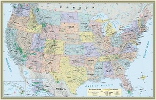
Zum Hauptinhalt springen
Nicht aus der Schweiz? Besuchen Sie lehmanns.de

Ergebnisse zu
Karten / Stadtpläne / Atlanten

Fachgebiete anzeigen
Folding poster map (438mm x 672mm) of 45 routes designed to complete all 214 Wainwrights in the most efficient way
von Vertebrate Publishing
Poster
2022 | Vertebrate Publishing Ltd
ISBN: 9781839811630
CHF 27,45 (inkl. MwSt)
  • Versand in 10-20 Tagen
Folding poster map (438mm x 672mm) with 32 routes designed to complete the best 121 Peak District Peaks and Ethels in the most efficient way
von Vertebrate Publishing
Poster
2026 | Vertebrate Publishing Ltd
ISBN: 9781839812972
CHF 22,90 (inkl. MwSt)
  • Noch nicht erschienen
Irish Historic Towns Atlas, no. 29
von Ned McHugh
Media-Kombination
2019 | Royal Irish Academy
ISBN: 9781908997746
CHF 72,25 (inkl. MwSt)
  • Versand in 15-20 Tagen
von British Library
Blankobuch/Tagebuch
2018 | Frances Lincoln
ISBN: 9780711239555
CHF 12,25 (inkl. MwSt)
  • Titel ist leider vergriffen;
    keine Neuauflage
von Christina Henry de Tessan
Lehr- oder Lernkarte
2011 | Chronicle Books
ISBN: 9780811874090
CHF 27,90 (inkl. MwSt)
  • Titel wird nachgedruckt
Map & Naturalist Guide
von Waterford Press
Sammelalbum
2016 | Waterford Press Ltd
ISBN: 9781583559888
CHF 31,90 (inkl. MwSt)
  • Titel z.Zt. nicht lieferbar
Map & Naturalist Guide
von National Geographic Maps; Waterford Press
Sammelalbum
2016 | Waterford Press Ltd
ISBN: 9781583559949
CHF 32,90 (inkl. MwSt)
  • Titel z.Zt. nicht lieferbar
Map & Naturalist Guide
von National Geographic Maps; Waterford Press
Sammelalbum
2016 | Waterford Press Ltd
ISBN: 9781583559994
CHF 32,90 (inkl. MwSt)
  • Versand in 15-20 Tagen
Irish Historic Towns Atlas, no. 28
von Jacinta Prunty; Paul Walsh
Media-Kombination
2016 | Royal Irish Academy
ISBN: 9781908996916
CHF 64,95 (inkl. MwSt)
  • Versand in 15-20 Tagen