Llangollen and Montgomery Canals von Geoprojects Karte (gefalzt) 1996 | GEOprojects (UK) Ltd ISBN: 9780863510335 CHF 8,25 (inkl. MwSt) Titel ist leider vergriffen; keine Neuauflage
Kenai Fjords National Park, Alaska von Press Pub Falcon; Trails Illustrated Karte (gefalzt) 1997 | National Geographic Books ISBN: 9780925873187 CHF 16,50 (inkl. MwSt) Keine Verlagsinformationen verfügbar
Great Routes in the Peak District von Al Churcher Karte/Kartografie 1998 | Goldeneye ISBN: 9781859650332 CHF 13,95 (inkl. MwSt) Titel ist leider vergriffen; keine Neuauflage
Kerry von Ordnance Survey Ireland Karte (gefalzt) 1994 | Ordnance Survey ISBN: 9780904996180 CHF 9,10 (inkl. MwSt) Titel ist leider vergriffen; keine Neuauflage
Kilkenny, Tipperary von Ordnance Survey Ireland Karte (gefalzt) 1996 | Ordnance Survey ISBN: 9780904996982 CHF 9,10 (inkl. MwSt) Titel ist leider vergriffen; keine Neuauflage
Galway, Longford, Roscommon, Westmeath von Ordnance Survey Ireland Karte (gefalzt) 1999 | Ordnance Survey ISBN: 9781901496253 CHF 8,60 (inkl. MwSt) Titel ist leider vergriffen; keine Neuauflage
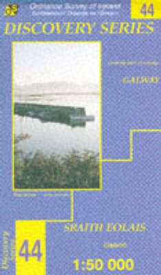
Galway von Ordnance Survey Ireland Karte (gefalzt) 1998 | Ordnance Survey ISBN: 9780904996647 CHF 9,10 (inkl. MwSt) Titel ist leider vergriffen; keine Neuauflage
Arrochar Alps von Harvey Map Services Ltd Karte (gefalzt) 1996 | Harvey Map Services Ltd ISBN: 9781851372300 CHF 9,95 (inkl. MwSt) Titel erscheint in neuer Auflage
Ordnance Survey Maps von David & Charles Publishing Karte (gefalzt) 1982 | David & Charles ISBN: 9780715346280 CHF 8,50 (inkl. MwSt) Keine Verlagsinformationen verfügbar
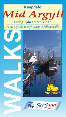
Walks Around Mid-Argyll Eight Easy to Follow Walks Karte (gefalzt) 1997 | Footprint ISBN: 9781871149319 CHF 10,40 (inkl. MwSt) Titel nicht im Sortiment
Organ Pipe Cactus National Monument von Trails Illustrated; Trails Illustrated Karte (gefalzt) 2000 | National Geographic Books ISBN: 9780925873712 CHF 16,50 (inkl. MwSt) Keine Verlagsinformationen verfügbar
Nicholson/Ordnance Survey Inland Waterways Map of Great Britain Karte/Kartografie 1993 | OS-Nicholson ISBN: 9780702821479 CHF 8,70 (inkl. MwSt) Titel erscheint in neuer Auflage
Dury and Andrews 1766 Map of Hertfordshire - Digitally Redrawn South East Sheet von Andrew Duncan Macnair Karte/Kartografie 2013 | Andrew Macnair ISBN: 9780957447745 CHF 43,60 (inkl. MwSt) Keine Verlagsinformationen verfügbar
Dury and Andrews 1766 Map of Hertfordshire - Digitally Redrawn North West Sheet von Andrew Duncan Macnair Karte/Kartografie 2013 | Andrew Macnair ISBN: 9780957447714 CHF 43,60 (inkl. MwSt) Keine Verlagsinformationen verfügbar
Kent Cycle Map Including the Crab & Winkle Way, Viking Coastal Trail, Chalk & Channel Way, Heron Trail, Plus Five Individual Day Rides Karte (gefalzt) 2012 | CycleCity Guides ISBN: 9781900623292 CHF 18,90 (inkl. MwSt) Titel ist leider vergriffen; keine Neuauflage
Amc White Mountain National Forest Trail Map Set von Appalachian Mountain Club Books Karte (gefalzt) 2012 | Appalachian Mountain Club ISBN: 9781934028568 CHF 43,85 (inkl. MwSt) Titel ist leider vergriffen; keine Neuauflage
Rhinebeck Panorama of Nelson’s London, c.1806 Karte/Kartografie 2013 | Old House Books ISBN: 9781908402400 CHF 14,65 (inkl. MwSt) Titel ist leider vergriffen; keine Neuauflage
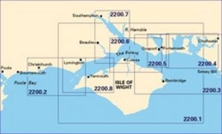
Imray Chart 2200.10 Rivers & Marinas in Southampton Water von Imray Karte (plano) 2011 | Imray, Laurie, Norie & Wilson Ltd ISBN: 9781846233814 CHF 29,95 (inkl. MwSt) Titel ist leider vergriffen; keine Neuauflage
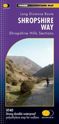
Shropshire Way Shropshire Hills Sections von Harvey Map Services Ltd. Karte (gefalzt) 2011 | Harvey Map Services Ltd ISBN: 9781851375073 CHF 23,20 (inkl. MwSt) Titel erscheint in neuer Auflage
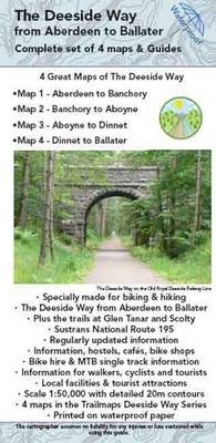
The Deeside Way Complete Set of Maps and Guides Pack of 4 Maps and Guides of the Deeside Way Karte (gefalzt) 2011 | Trailmaps ISBN: 9781906184780 CHF 19,20 (inkl. MwSt) Keine Verlagsinformationen verfügbar